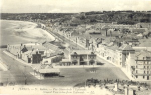
On the coast
|
 The Weighbridge
 An early map of St Helier before the land on which the Weighbridge stood had been reclaimed The Weighbridge is one of the most important locations in St Helier. The name has been taken by the whole area to the north of the Old Harbour and New North Quay, where the original public weighbridge formerly stood
|

This is all reclaimed land, the shoreline of St Helier having previously been over 200 metres to the north on the south wall of the town churchyard. Gradually, from the 18th century onwards, the sea was pushed back, as first warehouses, and then hotels and other properties, were built to the south of the church.
Then construction of St Helier Harbour began in the 19th century, and gradually more and more land was reclaimed - a process which is continuing to this day.
The weighbridge itself was ordered to be constructed in 1825, and, as the island's potato industry developed, for several weeks of every year it was the centre of island life, as farmers brought their crop to St Helier for weighing, packing and then shipping out of the island.
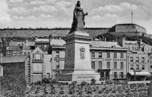
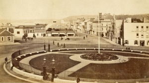
In 1870 the town terminus of the Jersey Western Railway was built; in 1877 a new weighbridge was built in front of the terminus, closer to the harbour and the original building was demolished; in the late 1880s a circular garden was laid out, initially with a tall flagpole in the centre, before it was replaced with a statue of Queen Victoria, which was unveiled in 1890.
The Weighbridge's darkest days were in June 1940, when thousands of islanders queued there awaiting evacuation, and it was later the scene of an aerial attack by German forces, which would shortly occupy the island, after ordering white crosses of surrender to be painted on the Weighbridge and Royal Square.
Five years later, when the island was liberated, the Weighbridge was the scene of great jubilation, as crowds flooded the area to see the Union Flag unfurled on the balcony of the Pomme d'Or Hotel which stands on the edge of the Weighbridge open area.
Today a memorial square with freedom statue has been constructed on this side of the Weigbridge, but the opposite side, in front of the Jersey Museum, where the statue used to stand, and leading towards Commercial Buildings is an open area awaiting redevelopment as a public arena. The statue was moved closer to the old railway terminus, then the tourism centre, in 1970 and its surrounding gardens demolished, to allow the bus station which was then located there to be enlarged. The weighbridge itself also disappeared in 1970. In 1976 the statue was moved to the Triangle Park at West Park.
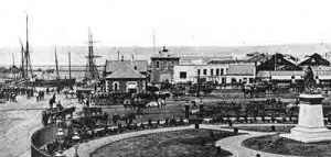
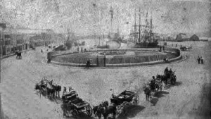
At first the Old Harbour stretched much further towards the Royal Yacht Hotel but a section was filled in during 1884 to allow the circular garden to be constructed. At this point there was only a narrow stretch of land between the harbour and the garden. In 1928 more of the harbour was filled in to create land for car parking.

Other articles
- The 'island site', the history of the abattoirs and other buildings on the site adjoining the Weighbridge
- Pictorial chronology of the Weighbridge, viewed from Fort Regent


Dated photographs


Click on an image below to see larger picture

The weighbridge (left of picture) with town houses and hotels behind in 1860

1865

1860s

1870

Carriages in 1875

Weighbridge hotels in 1876

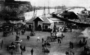
New weighbridge in 1877 Photographed by Ernest Baudoux. The single central weighing bridge would eventually be joined by two more at either side of the building

Potato carts queuing in the early 1880s

1880

Potato carts queue in 1880

An albumen print from the late 1880s

A picture by Ernest Baudoux from the early 1880s

1883 Picture by Ernest Baudoux

Looking down from Fort Regent in about 1880

c1905

Tourism offices 1969

Finsbury Hotel in 1969

Liberation Square construction in 1995


Dates confusion
The dates attributed to pictures of the reclaimed land on which the Weighbridge garden was located can be very misleading. Three of those below were part of a sequence taken by Ernest Baudoux, presumably at the same time as the larger image further up the page. They show the area of land reclaimed from the harbour, the top wall of which was moved several metres down to create the space where the statue of Queen Victoria would be erected in 1890. One of the images is dated 1884, another 1886, and the third, 1890, but they certainly appear to have been taken within a short time of each other, and the date of 1887 attributed to the larger picture above seems most likely. The dates for all pictures taken of this area in the 1880-90s must be seen as approximate, but a definitive date of 28 July 1889 for one of them cannot be accurate because the circular garden is known to have been laid out in 1888, with a flagpole at its centre until the statue was unveiled in 1890

1886


1885

This one is dated 28 July 1889, but that is wrong


1884-1890

1888

1890

1890s, from a Victorian slide

1893

1895

1895

The gardens in 1895

A picture by T Singleton, probably taken in 1895-96

1888: The gardens are there, but Queen Victoria's statue has not arrived. In its place is a tall flagpole

The Weighbridge gardens before a flagpole was replaced with Queen Victoria's statue


1880s

1890

Unveiling of Queen Victoria statue, 1890

The weighbridge in use during the 1895 potato season

1890

1890 albumen print


A ceremonial arch over the Queen Victoria statue for the unveiling in 1890

Queen Victoria statue, 1890

Looking over the newly erected statue of Queen Victoria towards the Old Harbour in 1890

A photograph by Godfray previously dated 1890s. But the familiar granite railway terminus has been built, which means the photograph was taken after 1901

1897

A picture of the Weighbridge Gardens in 1890

A picture by Albert Smith taken before 1900

In 1900, when this picture was taken by Albert Smith, the Old Harbour can be seen reaching to within feet of the new Weighbridge Gardens

c1886

1894

A picture of a virtually deserted Weighbridge and Albert Harbour in the very early 1900s. Why were there no ships in harbour?
A tinted 19th century slide showing a busy scene

1896

1896


c1900

Hotels in 1900

The gardens with mature bushes - an early 20th century photograph

1902

1903

1902

The view from the Star Hotel on the corner of Mulcaster Street in the early 1900s

A horse and van photographed by Edwin Dale in 1904


1905?
These pictures illustrate the difficulty encountered in trying to date photographs taken more than 100 years ago. They were all received dated 'circa 1905'. That date might be accurate for the pictures on the left and below, but the one on the right was taken much earlier, long before the frontage of the railway terminus had been replaced by the granite building which subsequently became the island's Tourism office, and still stands today. An investigation of the dates of various pictures of the Weighbridge elsewhere in this website put a date of 1879 on the centre picture


1906

A 1906 photograph by Albert Smith

An Albert Smith photograph from 1906

1907

The Weighbridge in 1907

A picture of the Weighbridge in 1907 by Philip Morel-Laurens

The 1907 potato season at its height

1908

1908

Photograph by Edwin Dale

1910

1910s

LL postcard

LL postcard

LL postcard


LL postcard

LL postcard

The Weighbridge in the 1910s

The Weighbridge in 1913

1921

1922

The Weighbridge shortly before the top end of the Old Harbour was filled in during 1928

1928

1930s

1930s

The Weighbridge viewed from the bottom of Conway Street in the early 1930s

The weighbridge in 1937

1937 Evening Post picture


The Pomme d'Or Hotel under construction in 1938 - Evening Post picture

1939 or early 1940

A small queue of potato lorries at the Weighbridge in 1940, probably taken just before the German invasion

November 1940

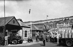
The bus station in the very early weeks of the Occupation

The Pomme d'Or and Southampton Hotels in 1941

1941

1942

12 May 1945

12 May 1945

Liberation Day, 9 May 1945

Potato lorries queuing at the weighbridge in the late 1940s

1948

1948

A 1950 view

1950s

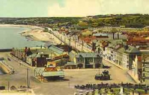
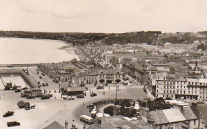
Looking down on the Weighbridge with the Esplanade beyond, in the 1950s

A 1950s Tuck postcard

1950s

The 1950s

Queen Victoria's statue and surrounding gardens in 1953

Lorries queuing with tomatoes for export


.jpg)


1953 and buses are parked on the far side of the Weighbridge Gardens in this Evening Post picture

1955

A BEA airport coach outside the Weighbridge terminal in 1955

A Jersey Airlines airport coach outside the Weighbridge terminal in 1955

A car rally departs from the Weighbridge at Easter 1958

1960s

1960s

The 1960s

This postcard from a 1960s photograph was still on sale in 1985

The Tourism office in the 1960s

The Star Hotel in 1961

The high tide floods over the harbour edge in 1962

The Weighbridge at night in 1963

The Weighbridge in 1964

1964

1965

A 1967 photograph by Robin Webster

1967

1967

1968

Queuing for a bus in the 1960s


1969

1969

1969

1969

Although published in a 1975 magazine, this photograph is several years older. It was clearly taken before the opening of The Tunnel in 1970

1970

1970s

The 1970s

Buses crowd the Weighbridge during a strike in the 1970s

The statue of Queen Victoria moved from its original position in the centre of the circular gardens to a temporary location in front of the Tourism offices in the former railway terminus, before another move to West Park


Dismantling the statue and plinth in November 1972

The late 1970s saw Queen Victoria's statue and surrounding gardens make way for more bus parking

The statue in 1973, after its first move

Weighbridge 1982

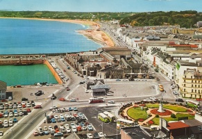
A 1984 Jersey Evening Post aerial view of the Weighbridge, showing the whole area given over to buses, parking and a container park

1989

Liberation Square, created to celebrate the 50th anniversary of the Liberation

Liberation Square

55th anniversary celebrations in Liberation Square in May 2000

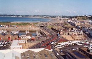
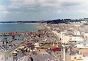
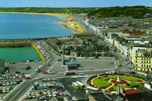
The Weighbridge area in 2012

1970

1970, and the weighbridge itself is demolished

1973

Snow covers the Weighbridge in the late 1970s or early '80s

1982


Potato exports


Horse-drawn carts with barrels of potatoes queue for their turn on the public weighbridge


A queue of potato carts


Potato carts

Potato carts

An earlier photograph attributed to Edwin Dale showing farmer's vans laden with potatoes waiting to use the weighbridge. He cannot have been the photographer, because it has to have been taken before 1877 and he was not born until 1882

A lorry using the weighbridge

Potatoes awaiting export


Sundry photographs not yet dated
Click on an image below to see larger picture

A crowd gathers round men with penny farthing bicycles outside the Southampton Hotel

19th century view

The new weighbridge had a single bay when first built

Two bays added to the sides of the new weighbridge

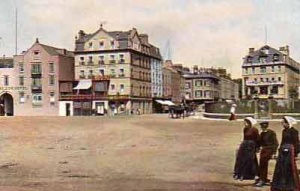
Caledonia Place hotels behind the gardens


A picture by Edwin Dale


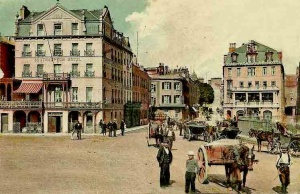
Carriages for hire queue around the gardens


Carriages in Victorian times

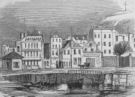
Sailing ships line both sides of the New North Quay

Weighbridge Gardens, sometimes known as Queen's Gardens or Victoria Gardens after the statue of Queen Victoria

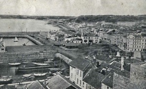
The weighbridge with the top of the New North Quay and the Albert Harbour beyond and the Albert Pier in the background

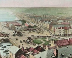
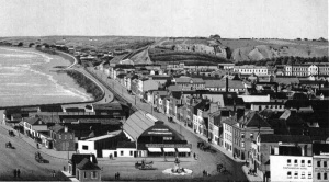
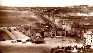
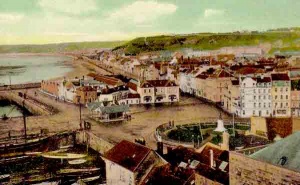
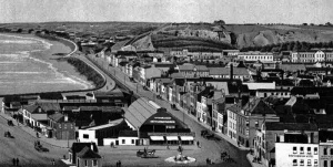
Looking down on the Weighbridge from Fort Regent. The land in the left foreground was created by infilling the top of the Old Harbour

Weighbridge Gardens with the statue of Queen Victoria, and warehouses on the New North Quay (now the Maritime Museum and Occupation Tapestry Gallery) in the background

The early 20th century


Edwardian modes of transport with the Royal Yacht Hotel in the background

Looking down on the gardens

Weighbridge Gardens


Late 19th century

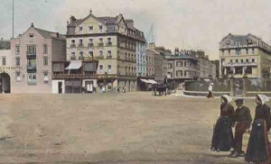
Militiamen at the Weighbridge, opposite the junction of the Esplanade and Conway Street


.jpg)


Queen Victoria's statue in Weighbridge Gardens

A steam clock has been built on the infilled area at the end of the Old Harbour

Buses occupied much of the Weighbridge for the second half of the 20th century

Liberation Day crowds

The Weighbridge Gardens and Queen Victoria statue, overlooked by Fort Regent

An Ernest Baudoux photograph including the Southampton and Royal Yacht Hotels and shipbroker W T Pugsley

Picture of the weighbridge by Albert Smith

Picture of the weighbridge by Albert Smith

Picture by T Singleton

Picture by Ernest Baudoux


Picture by Ernest Baudoux

The drag hunt used to meet at the Weighbridge, as shown in this Albert Smith photograph

An Ernest Baudoux photograph showing Shaw's Navy, Adderson's Star and Royal Yacht Hotels and the new sailors' home

Picture by Ernest Baudoux

Picture by Ernest Baudoux

The Royal Yacht Hotel

The Weighbridge Gardens before the statue of Queen Victoria was erected in 1895

Cars parked on an area created by infilling the top of the Old Harbour in the 1930s

Post-war car and bus parking. Note that there are no road markings

An advert for the Southampton Hotel offers rooms from 6s 6d to 7s 6d a day

Sailing vessels pack both sides of the New North Quay for this Ernest Baudoux photograph

A picture by Edwin Dale of a family group in the Weighbridge Gardens

Picture of the gardens by Albert Smith

Picture by Albert Smith

A postcard by H G Allix of the gardens

A view of the front of the Pomme d'Or and Southampton Hotels on an H G Allix postcard

A View from Fort Regent


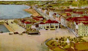


Weighbridge Gardens


Liberation Square


The drag hunt meets at the Weighbridge

An aerial view


The Southampton Hotel

Weighbridge receipt


Albert Smith picture


A policeman directing traffic at the Weighbridge

The Weighbridge photographed by Singleton

Weighbridge

Photograph by Ernest Baudoux

Photograph by Ernest Baudoux

Photograph by Ernest Baudoux

Photograph by Ernest Baudoux


Photograph by Ernest Baudoux

Photograph by Ernest Baudoux


Hotels


An early postcard

An albumen print


Hill Street in the foreground

Looking down on the row of hotels, Southampton on the left

The view today

Charabancs at the Weighbridge

The gardens

Photograph by Philip Godfray

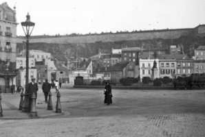
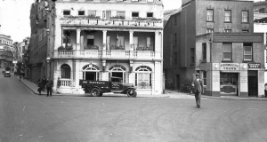
A policeman on point duty

The old Weighbridge, a painting by Philip Henry Poore

This postcard was sent to a relative by 'Jack' who had a holiday job in the offices behind the weighbridge


