From Jerripedia
Archive pictures of the week - 2020
5 January 2020
Early images


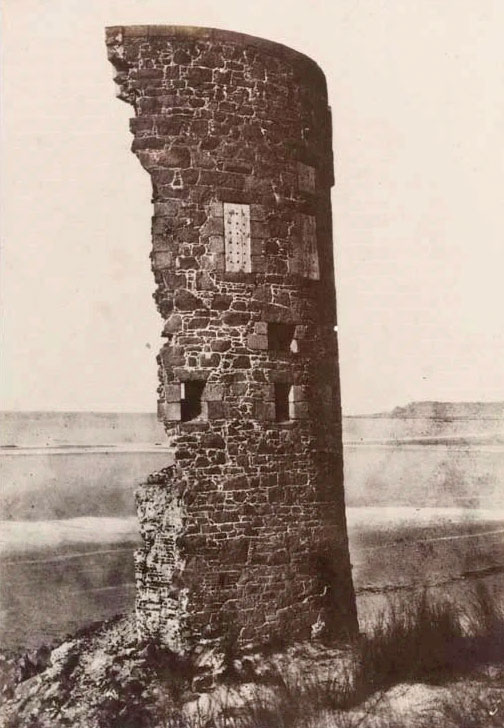
At first sight there does not appear to be any connection between the two pictures with which we start off our weekly feature in 2020. Both show crumbling granite, but that is not the link. These photographs are both old - very old - and are believed to have been taken within a couple of years of each other in the mid-1850s. That means that they are contemporaneous with photographs taken by
Victor Hugo and his entourage during their stay in Jersey between 1852 and 1855, which are generally recognised as the earliest surviving outdoor views of the island. The photograph of a thatched cottage is of such amazing quality that we had previously doubted the date attributed to it of September 1855, but further information which has been discovered by our researcher Gary Mayne supports the date. The photograph, of an unknown building, was taken by Joseph Cundall, a pioneer photographer in London, and a founder member of the Royal Photographic Society. The photograph is in the New York Metropolitan Museum of Art. According to an inscription on the print, it was produced using the collodion process, which was invented in 1851. The museum holds an albumen silver print made from a glass negative, acquired through a bequest in 1952. The picture below of a crumbling Jersey coastal tower is believed to be a year older. The photographer is unknown, but the print is believed to have been produced in 1854 using the Blanquart-Evrard process. This was Tour du Sud, originally Tower A at the southern end of St Ouen's Bay, on the shore opposite La Rocco Tower. Tour du Sud, as well as Towers B and C to its north, were undermined by the sea. It is not known how long Tower A survived in the condition found by the unknown photographer in 1854, but the major damage is believed to have occurred in 1851
13 January 2020
Gorey tower


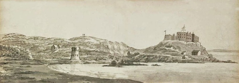
Two pictures again this week, both clearly of Grouville Bay - drawings from opposite directions. Both are not particularly exceptional, except that they clearly show a coastal tower on the shoreline, close to
Mont Orgueil Castle. This is the famous (or infamous) Grouville No 8 tower, which no longer stands there. Its fame (or infamy) is derived from the fact that nobody knows exactly when, or why, it disappeared. The full story - or as full as we are able to make it - can be found on our page
What happened to the St Martin tower?. Yes, St Martin, because the tower is always known as Grouville No 8, it actually stands just over the border in the adjoining parish. These two drawings are particularly valuable because, although the tower must have been photographed many times, we have yet to find a photographic image showing it as anything more than a fuzzy structure in the distance. The bottom drawing is by Charlotte Mervin Nooth, about whom nothing is known except that a sketch book of 53 views of Jersey and Guernsey including this one, was sold by Christie's in 2010. The top one is by an unknown artist and engraver
20 January 2020
Hotel interiors
Sadly we do not have dates for all of the four photographs below which show the interiors of Jersey hotels, but we suspect that they are from the 1930s, except the one showing the Aberfeldy Hotel lounge, which is dated 1951. The pre-war years were a peak period for tourism and hotels had to be very competitive in facilities and services to attract their customers. Only the Revere Hotel is still in business in 2020, surviving despite earlier plans to demolish it as part of the development of a new hospital.
Chateau Rocozanne Riviere Lounge - this hotel was in St Brelade's Bay
Hotel Revere residents' lounge - Kensington Place, St Helier
Aberfeldy Hotel lounge - was on New St John's Road
Chelsea Hotel courtyard lounge - was in Gloucester Street
27 January 2020
Sand yacht

This looks like a lot of fun. Unfortunately this photograph of a rather large (at least by today's standards) sand yacht in
St Ouen's Bay is undated, but the ladies' costumes suggest 1930s. The yacht has all the appearance of being a home-made job, with pram wheels, a substantial chassis and, perhaps, a dinghy mast and sail. Presumably it was designed for single occupancy when it was actually in motion. We suspect that with an experienced person at the wheel it would have traversed the beach at some speed on a windy day.
3 February 2020
King Street hotel


There used to be a number of hotels in the centre of St Helier, including
King Street, the
Royal Square and
Halkett Place, but now there is just the new Premier Inn at
Charing Cross. For a long time one of the most popular was the
Hotel du Palais de Cristal, at 62 King Street - now occupied by Boots the Chemist. It was a hotel designed to cater for French visitors to the island, who were probably more numerous in the 19th century than those from the UK. This poster, probably dating from the early 20th century, shows that French guests were still a priority, with the daily rate quoted in Francs. A later version of this poster shows the English equivalent as 6 shillings a day. What is particularly fascinating about this advert is the warning at the bottom
Ne pas écouter, sur les paquebots, les pisteurs qui sont payés pour détourner la clientèle, which translates as 'Don't listen on the passenger boats to the touts who are paid to hijack guests'. Clearly the competition for trade was intense
10 February 2020
Potato merchant

This photograph was taken on the Esplanade, probably shortly after World War Two, judging by the make and models of lorries shown laden with potatoes. The 'fifties and 'sixties were peak years for Jersey's new potato industry, and throughout the season the Esplanade, which was home to the major produce merchants, of which John Terry was the largest, was crowded with farmers' lorries going to-and-fro to the Weighbridge to have their crop weighed, then to the merchants for packing, and then back to the Harbour to be shipped to the UK. Pictures of the queues which formed on the main routes to town from the country parishes, and outside the weighbridge abound, but photographs of activity outside the merchants' premises are not so common
16 February 2020
Picture of the decade


To celebrate Jerripedia's 10th birthday on 15 February we have selected a Picture of the Decade. Pictures did not become an important feature of the site until August 2010, when a historical photograph of All Saints Church was the first to be added. It was another year later that this popular Picture of the Week page was introduced, with an etching of Elizabeth Castle and St Helier Harbour as they looked in 1786. We set out to work through the annual archive pages which contain all the images chosen as the feature picture each week but only got as far as No 2 in the sequence, this photograph of Jersey golfer Harry Vardon teeing off at the first hole of the Open Championship in 1903, and decided to look no further. This is a superb photograph of arguably the most famous Jerseyman of the 20th century. We have never been absolutely certain, but that looks suspiciously like King Edward VII on the left. This was the year that Vardon, who learned his craft on Grouville links, won the fourth of his record six Opens.
23 February 2020
Grouville links

We continue the golfing theme from last week's Picture of the Decade with a view of Grouville Links in the 1930s. It is one of a number of images of the Royal Jersey course which came our way this week, several of them taken in 1920. Most of these were already in our
page of pictures of the seaside course, but of better quality, which has enabled us to update the page and add those from the new selection which were not already included. For those not familiar with the island, the course is towards the top of Jersey's east coast and that is Gorey Village and
Mont Orgueil Castle in the background
1 March 2020
Banknotes for all


In the 19th century any man (and probably his dog) seems to have been able to issue his own banknotes. The idea was simple. Print your own notes, swap them for 'real' Bank of England notes, and put those on deposit to earn interest. The States still do it today - it's the main reason for Jersey having its own currency - but all the organisations, local banks, and even individuals who played the game in the 19th century would no longer be able to do so now. I'm sure the Bible Christian Society were/are a very worthy group of individuals, but it seems very strange that they should issue their own banknotes. Parishes issued notes to finance their projects; notes were issued to finance the building of the Esplanade and the Masonic Temple; notes were issued by bona fide Jersey banks; and notes were seemingly issued by individuals, under the umbrella name 'Jersey Bank'. Some notes had a face value of as little as half a crown (2s 6d), very few as much as this one's £5. It all ended in tears, of course, with a number of bank failures from the 1870s onwards almost causing the island's economy to collapse. This note was one of hundreds collected by Jersey benefactor Sir David Kirch which was sold at auction last week to boost his charitable fund. See
Jersey Currency for pictures of dozens more notes and
Banking collapses in the 19th century for more information on the problems they helped cause
15 March 2020
Rosa Cottage

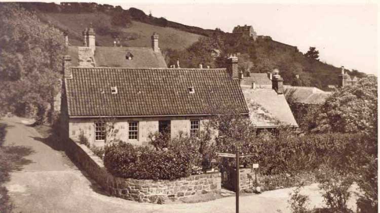
The appearance of this photograph on the Jersey Temps Passe Facebook page caused us to look through our collection of house pictures not yet allocated to particular pages, and there it had been sitting awaiting identification for two years. The consensus was that this photograph, taken in 1906, shows Apple Cottage, at Rozel, which became a popular restaurant and tearoom later in the 20th century. It was some time later that the building was positively identified as Rosa Cottage in Vallee des Vaux, which had the distinctive tiny windows in the thatch, north and south, and featured in several postcards of the Valley. The picture below shows how Apple Cottage looked in the 1950s and, with the benefit of hindsight, the differences are obvious.
De Faye water

Along with several other St Helier pharmacies, de Faye, of David Place, were renowned for their perfumes and produced eau de cologne for export in the 19th century. But de Faye was also known for its bottled water, produced from its own spring. A fascinating booklet advertising this product was recently handed into the care of Jersey Archive, and we weere sent a copy to ensure that it gets a much wider audience than it does hidden in their strongroom. Images of all pages, including instructions for healthy living, can be found on the
de Faye family page
23 August 2020
Weighbridge

This picture, taken in the early years of the 20th century, is a real blast from the past. Not only are potato exports no longer weighed on an open public weighbridge adjacent to St Helier Harbour - it has long disappeared to make way for 'road improvements', but they are certainly not taken from farms to the Harbour by horse and cart. The first public weighbridge was built in 1825, and as more land was reclaimed in the area, it was replaced by a new structure in 1877. Initially that 'bridge had just one passage, but the continuing growth in the island's new potato industry led to the construction of two more channels on either side. Nevertheless, at peak export times it was not uncommon to see traditional potato vans, and the lorries which eventually replaced them, stretching back a mile or more from the Weighbridge to the east, west and nort of St Helier
6 September 2020
Land reclamation


We are back at
the Weighbridge this week, with a view which is unusual in many respects. There is no shortage of photographs of the Weighbridge area from Fort Regent, but most only show the view out over Commercial Buildings, the top of the harbour, the Weighbridge area and the town. This one shows the outer wall of the Fort and puts everything into perspective. It was taken in 1887. We can tell that because it shows work completed on the reclamation of land at the top of the Old Harbour, the end of which is now level with the Albert Harbour beyond. The reclaimed land has yet to be laid out with a circular garden. That happened the following year, and a tall flagpole was erected in the centre. In 1888 the States then decided to erect a statue of Queen Victoria and that replaced the flagpole in 1890. So, contrary to popular belief, the top end of the Old Harbour was not filled in with the specific intention of providing land for the statue of the Queen. Whether the gardens were part of the original plan is unclear, and whether the flagpole was intended to be permanent, or was simply placed at the centre as a temporary feature awaiting the arrival of the statue, is also uncertain. There are many views over the years of the Weighbridge from a similar vantage point in our
Weighbridge picture gallery, and photographs from the 1880s showing the land reclamation, but, as far as we know, this view is unique in showing the infill just completed from above. Sadly, even with a degree of enhancement, the quality of the photograph is not good enough to enable much detail to be made out in the town of St Helier beyond its Harbour


