
This is a gallery of general views of St Aubin and its harbour. For further pictures see St Aubin's High Street, Railway picture gallery and St Aubin's Fort.
St Aubin's Harbour in the Victorian era


Click on any image below to see larger picture
These pictures of St Aubin during the German Occupation come from an official German army collection. For the full set of pictures of German installations across the whole of the island, follow this link


Images of the town
This new set of images of St Aubin was obtained in 2019


Dated pictures

A very early drawing showing galleons at anchor off St Aubin

Francis Ford's 18th century picture of a boat beached close to the end of the north jetty. The picture appears to show no south jetty, but this was completed some time before the north pier was started

A view of St Aubin in 1809

1809

St Aubin in 1817

St Aubin in 1840

An 1842 lithograph from a drawing by John Neel

19th century drawing

19th century

St Aubin viewed from La Haule in the mid-19th century

St Aubin painted by Ouless in 1847

The fort from an 1856 guidebook


A picture taken by George Bashford between 1859 and 1863

1860s


1870

1870

Picture by Mrs Slater, c1870


A photograph by Ernest Baudoux of the seawall under construction in 1872

The sea wall from St Aubin's Harbour to La Haule had just been completed when this photograph was taken, but the triangle behind the Railway terminus had yet to be filled in

This picture was taken some time after. The triangle has been filled in and trees planted on the mound of soil created. Buildings have also been constructed on the reclaimed land and trees have been planted on the roadside of the terminus

This picture was taken after the terminus was built in 1870 and before the line was extended across the road in front of the building in 1884

1877

1870s


Girl at a well in St Aubin in 1880

1880s

1880

1882

1887

From a 1890s stereoscope

1893 - the railway terminus/hotel on the right and the area known as Charing Cross in the centre

1894

1894

The harbour in 1895

1900 slide

1900

1900


The Bulwarks in the 1900s

1902

1902

1903

1903

St Aubin in 1904

Swimming in the harbour in 1904


1905

1900s

1906 photograph showing the level crossing gate for trains leaving for Corbiere

1907


1907

1907

St Aubin in 1909

A strange subject for a postcard in 1910

1910s

LL postcard - 1910s

LL postcard - 1910s

LL postcard - 1910s

LL postcard - 1910s

LL postcard - 1910s

LL postcard - 1910s

LL postcard - 1910s

LL postcard - 1910s

LL postcard - 1910s

1910s

St Aubin in 1923

1924

1926

St Aubin in 1929

1930

1930

1930

1931 water carnival. Photograph by Percival Dunham

St Aubin's Fete in 1933

The harbour in the 1930s

The railway terminus has gone by the 1930s but the area has yet to be turned into a car park


St Aubin in 1935

Barbed wire during the Occupation

Railway track along the Bulwarks in the Occupation

1944

The Bulwarks in 1950

1950s

The yacht club in the 1950s

Back of the harbour in the 1950s

The view from the Somerville in 1953

Buses outside the old railway terminus in 1954

1955

1955

1955

1955

1957

1957

1957

1950s

St Aubin Fair in 1958

1959


From a 1961 tourism brochure


1961 St Aubin Carnival

1964

1966

1967

1967 dredging

1967 dredging

The opening of National Westminster Bank's branch in 1963

Majorettes at St Aubin Fete in 1977

1970s

1970s

1970s

Methodist Church 1970s

Le Boulevard 1970s
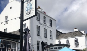
Old Court House 1970s


Le Quai Bisson steps 1970s

Le Quai Bisson 1970s

Datestone in the harbour wall

1970s

1973

1988

1988


Undated miscellaneous images of the town and harbour


A sailing ship in the harbour in the 19th century

The harbour and boulevard

The seawall on the St Aubin's Bay side of the harbour


A carriage passes along the Bulwarks - picture courtesy of Jersey Temps Passe Facebook group


The seaside town

Bulwarks

A lantern slide


The former railway terminus can be seen in the foreground


The pierhead


The Sacred Heart convent

A view along the Bulwarks

St Aubin Fete

St Aubin Fete

This pump provided fresh water for commercial ships and other vessels moored in the harbour. Not suitable for drinking now, if it ever was

The harbour area viewed from the beach

A 21st century market


The former Terminus Hotel, now St Brelade's Parish Hall


The old railway shed was demolished in 1938

Laying the foundation stone of the first St Aubin chapel


The back of the harbour


The Methodist church


Picture courtesy of Jersey Temps Passe


A bus outside the St Aubin terminus, competing for business


St Aubin at night

The Bulwarks


The Terminus Hotel

The Bulwarks


The former St Aubin Market, now leased by The States to NatWest Bank

The Market


The harbour today

Mont du Boulevard

Mont du Boulevard

High Street

Seafront


The former railway crossing at the foot of Le Mont des Vaux

Market Hill

Ghost Hill

St Aubin with St Aubin's Bay behind


A corner of the harbour behind the railway terminus is reclaimed

A distant view of the fort and town of St Aubin

An early drawing showing a rather square harbour

Looking down on the town and harbour


Market Hill

Bulwarks

Ghost Hill


A Victorian lantern slide of a well at St Aubin


The Bulwarks

St Aubin's Fort


A Le Masurier's decorator's business at Devonia House

A Victorian coloured lantern slide


Harbourmouth


St Aubin's Station and harbour in the 19th century

The level crossing gates in front of the railway terminal can be seen in this picture

Saint Aubin's Fete

'Albert Pier' has been written in error on this 19th century photograph of St Aubin's Harbour


A drawing of St Aubin viewed from Beaumont

Mid 19th century


A Tuck postcard of the harbour

The roadside of the station

A view of the back of the harbour and Belcroute from Noirmont

The Bulwarks

A 19th century print of the town and harbour


A Victorian lantern slide


Late 20th, and 21st century


St Aubin's Village

The harbour


St Aubin viewed from the grounds of world-famous author Jack Higgins' house


The Parish Hall in the 21st century

A helicopter lands close to the harbour entrance


The pierhead at high tide


Fete

1928


Maps and plans

20th century map

Late 18th century

Late 19th century

1837 map of St Aubin

Map showing the village and Mont Les Vaux

A map of land ownership

A map of land use


St Aubin from the air


1982

1996

2007

2007


An aerial view of the harbour taken from a kite

1933 aerial photograph by Aerofilms

1933 aerial photograph by Aerofilms

1933 aerial photograph by Aerofilms

1969

1969

1969


1966


1960s

1960s


1977


Pictures taken by town planners in the late 1960s

1966

1966

1966

1966

1966

1966

1968

1968

1968

1968

1968

1968

1968

1968

1968

1968

1968

1968

1968

1968

1968

1968

1968

1968

1968

1968

1968


Mont Les Vaux

Mont Les Vaux

The road is crossed by the railway bridge

1880

1905

An unusual view of St Aubin looking down on the bottom of Mont Les Vaux


